Property API Metrics

Clients
1

Every day our clients are saving money and time using our Property API

Years
1

How long our Property API has been serving up Certificate of Title & Property Information.

Total Hits
1

Information requests from our clients users loading Certificate of Title & Property Information.

Hits per day
1

Our Property API is serving up information on a daily basis.

Per Year
1

On average our clients save $11,5000 dollars per year on purchasing Certificate of Titles.

The Emtel Property Title Preview API is being used in a number organisations serving up property title information to staff at the click of a button.  Our “Early Adopters” have been enjoying the benefits such as, saving time and money when searching and viewing any property’s Certificate of Title information.

Early Adopters

Waipa District Council
Waitomo District Council
Waikato District Council
Matamata-Piako District Council

What our customers are saying

WDC purchased the Property Title Preview API from Emtel about a year ago. In that time the API has provided Whakatane District Council with a cost-effective way to retrieve Record of Title information for various departments across the organisation. The integration with our internal browser-based GIS is seamless and pain-free for users. No training required. Having used it for a year we are very satisfied with the results.

June 2020
Stephen O'Leary
Team Leader GIS, Whakatane District Council
I use this function every day without fail. A few examples:
- Finding out who owns parcels
- Seeing what covenants/consent notices are on titles
Alone I have probably saved an easy $10-20 a day from not downloading titles from land online. With the project I have coming up, could potentially save a lot more.  Annnndddddd it is very convenient and easy to use.

June 2020
Reserves Planner
Whakatane District Council
I think it is great - a lot quicker when you need to check things on the title- you don’t have to do the whole log in process.
It is Brilliant - Thanks you for making this available.

June 2020
LIM Coordinator
Whakatane District Council
Waikato District Council has been using the EMTEL Property Services API since December 2018. The API is used within our primary mapping tool Intramaps. The primary users at the council are Legal, Rates, and Resource Consents (including LIMS). The main benefits the council has realised from using the API are easier and more frequent looking up of title information without accessing and incurring the cost of Land Online. This API replaced a similar product that required updates and was always out of date. The API also comes with a useful stats portal to provide insights in the usage volumes and target areas.

December 2019
Mark Willcock
Former CIO, Waikato District Council
I use the app all the time, I haven’t used Landonline for a very long time now.

June 2020
Rates Officer
Whakatane District Council
Our planners now have LandOnline information at the click of a button. We used to log helpdesk calls for our Land Officer to download the data for us which could often take hours or days. Thanks emtel for a great tool.

October 2019
Senior Planner
Hauraki District Council

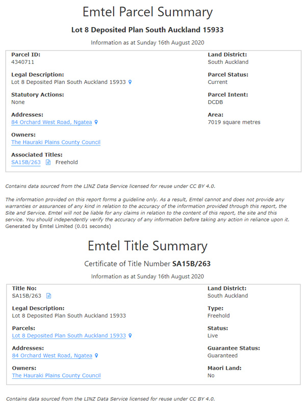
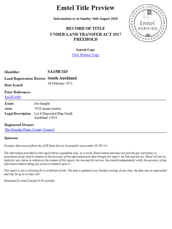
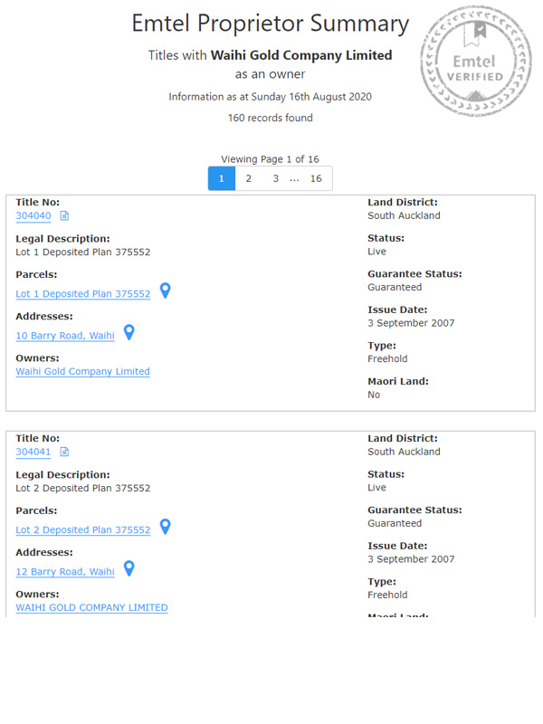
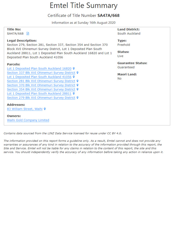
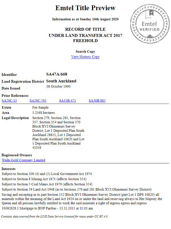
API Output Screenshots

Question & Answers

  1. View Certificate of Title information, Parcel details, related Owner information, and more.
  2. SAVE TIME by letting all users access information with a click of a button.
  3. Reduce the need to have a high number of LandOnline subscriptions.
  4. You wont get charged for requesting the wrong information.
  5. Information returns instantly without the need to search.
  6. Easy to configure, 5 minute setup.
  7. Can be used with either the Internal Web GIS or your Property system.
  8. NO DOWNLOAD COSTS EVER!
  9. Pay monthly for UNLIMITED DOWNLOADS by UNLIMITED USERS.
  10. 24/7 access with no logins needed.

Typically your Land Officer will be the main user of this system where they will be able to check any property’s information before downloading the actual Certificate of Title from LINZ.  However, this service provides you with great flexibility and allows you to deploy the service via a URL inside any application that has a Parcel ID or a Title Number.

Who else would use this service?

  1. Customer Services – to access and print property and title information quickly.
  2. Planners – for easy access to subdivision related information.
  3. Finance – to query what properties an owner has.
  4. Other staff members who need access to this information.

Current View: Shows the current owners, legal description, registered rights & restrictions e.g. mortgages.

Historic View: Shows all interests that have been registered against the current title since this title was created/issued.

  1. We update our Data Warehouse on a regular basis to ensure that all Title, Parcel, and Owner information is current.
  2. Automated smart algorithms create, merge, and mash data together to create the output that you receive.
  3. Data is transferred to your web browser via our API and using your unique API Key.  This is monitored for you so you can track all usage of the service to see if you are getting the best value for money.
  4. Our super fast servers are located in Auckland, yes that’s right here in New Zealand, so you experience lightning fast delivery of your reports.

There are four different types of computer register, depending on the classification of the land:

  1. Computer Freehold Registers (CFRs) for freehold land.
  2. Computer Interest Registers (CIRs) for leasehold land, or for any land of a lesser interest than freehold.
  3. Computer Unit Title Registers (CUTRs) for stratum freehold or leasehold interests in a unit-titled development.
  4. Composite Computer Registers (CCRs) a combination of the other three types, for example, a cross lease title is a combination of freehold and leasehold computer registers.

Yes, as long as you have the ability to create a hyperlink from your Parcel or Title table then you will have no problems setting this up.  We also have a list below of applications that can set up this Web Service.


IntraMaps – Create a hyperlink in the Info Query where you append the Parcel ID or Title Number to the end of the pre-defined Web Service URL.

Geocortex – Create a Feature Link on your Parcel or Title layers and append the Parcel ID or Title Number as a parameter.

Local Maps – Create a Feature Link of a Feature Layer.

QGIS – Create an Action so that users can run with a selected object e.g. Parcel row.

MapInfo – Create a Hot Link from your Parcel table using the Parcel ID as the parameter.

ArcMap – Use the Hyperlink tool and configure the URL with our web service url and the parameter needed e.g. Parcel ID.

Property Systems – Most Property Systems allow configurable hyperlinks using parameters.  Emtel have worked with a number of Property Systems like Authority, MagiQ Enterprise, and Technology One and can help you configure these applications to get our service running.


Note – we include documented setup and support during the configuration phase to ensure that you have the service running well.

If you dont have an application or system to create a hyperlink that is passed a parameter then you wont be able to use the Web Service URL.

We do offer an online web application that will provide you with a search tool so you can look up a Land Parcel, Title, Owner, or Address and see the same results as the Web Service.  The only difference is that you log into a portal rather than your own software.

For more information on the Online Web Application option please contact us.

Request a Call Back